Even if Nepal-India ties have been often described as ‘special’, the two nations occasionally butt heads over an array of issues ranging from border disputes to India’s meddling in Nepal’s internal affairs. In their latest spat, they are engaged in the fierce battle of maps that incorporate strategic territories lying on the far northwest of Nepal bordering India and China. On May 20, Nepal’s government updated its political and administrative map to include Limpiyadhura, Lipulek and Kalapani, covering 372 square kilometres, which it said were erroneously left out in the past maps.
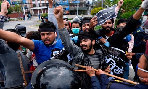
This was a bold, blunt reply to India’s unilateral decision in November to publish its new administrative map including these areas in its territory. India introduced the map to attempt to legitimise the changed status of Jammu and Kashmir, but was hoisted by its own petard. Widespread agitation and uproar swept across Nepal against India’s new map, which was denounced as an affront to the nation’s sovereignty.
Nepal decided to make public its new map under mounting public pressure after India ignored its call for diplomatic talks on the long-running territorial dispute. A bitter legacy of British colonialism, the Nepal-India border issue was never amicably resolved as Indian rulers before and after independence allegedly resorted to cartographic manipulation to capture Nepali territories already settled by the Sugauli Treaty. According to the treaty, signed between Nepal and the East India Company on March 4, 1816, and a couple of Survey of India maps, Kali River originating from Limpiyadhura marks the border between Nepal in the east and India to its west. The above territories claimed by India lie to the east of the river.
In the past, Nepali regimes of different hues were unwilling to incorporate Limpiyadhura in the map for fear of inviting Indian hostility. With a sweeping electoral mandate, the K.P. Sharma Oli-led government tackled the border issue head-on, collecting eight historical evidences and 132 maps to strengthen its position in future negotiations with India. The day before the new map was introduced, Prime Minister Oli told parliament that these territories belonged to Nepal and that his government would not back down from its campaign to reclaim them. He insisted that the territories were made to appear disputed after the Indian army occupied them without grounds in 1962. “Nepali side used to collect taxes, register voters names, conduct census and issue land registration certificates to the residents in the villages now controlled by India,” he said.
Nepal is standing up to India’s territorial encroachment.
However, India has rejected Nepal’s new political map, terming it an “artificial enlargement of territorial claims”. Indian Ministry of External Affairs spokesman Anurag Srivastava said the “unilateral” act of Nepal was not based on historical evidence. He argued that it was contrary to their bilateral understanding to resolve outstanding boundary issues through diplomatic dialogue, but kept mum about the new map released in November and Indian Defence Minister Rajnath Singh’s inauguration of a link road passing through Lipulek to Lipulek pass, a Nepal-China border point.
The current dispute came to a head following the inauguration of this link road on May 8, constructed to facilitate Indian pilgrims travelling to Kailash Mansarovar in the Tibet Autonomous Region of China. But the move triggered fresh objections from parliament to the street, prompting Nepal’s foreign ministry to issue a protest note to the Indian ambassador in Kathmandu.
But it was Indian army chief Gen Manoj M. Naravane who added fuel to the fire when he stated that Nepal’s objections were made at the behest of someone else, alluding to China. Naravane’s remark was a military reaction to a diplomatic question that only exacerbated the tension. But his flippancy led to an unprecedented level of unity among Nepali political parties, civil society and media against foreign hegemony and interference.
Indian adventurism has left many Nepalis shell-shocked for it took place at a time when they are struggling to come out of the Covid-19 crisis that has thrown their life out of gear, with the economy set to suffer a long-term recession. Now they are worried about possible Indian retaliatory moves against Nepal’s act of defiance. Some are making wild guesses as to whether India would again resort to a blockade as that of 2015, which followed hard on the heels of the devastating Gorkha earthquake.
Despite all the bitterness and acrimony, India has not ruled out a diplomatic course to resolve the boundary issues. Both the countries share a porous, open border with high-level political understanding and centuries-old cultural, social and economic interactions among their people. This enriched sociocultural capital is expected to serve as an antidote to any potential military confrontation.
The writer is deputy executive editor of The Rising Nepal.
Published in Dawn, May 31st, 2020


