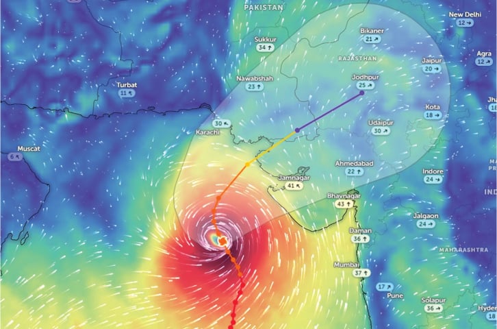
Rains from today as cyclone heads toward Sindh coast


• Chief meteorologist says 60-80kmph winds may hit port city
• 32,466 people in three districts, 70 buildings in Karachi to be evacuated, says Murad
• Emergency declared in hospitals, 500 shifted to safety from Keti Bandar
KARACHI: Even though the eye of the storm is likely to miss Karachi and parts of Balochistan, the Pakistan Meteorological Department (PMD) said on Monday that the intensity and severity of Biparjoy remained intact, and it is expected to make landfall on June 15.
The Sindh government has begun gearing up for the looming civic crisis in the southern parts of the province, with Chief Minister Murad Ali Shah announcing that 32,466 people in the districts of Sujawal, Badin, and Thatta, as well as residents of around 70 buildings in Karachi, were vulnerable to the cyclonic storm.
According to a PMD alert released on Monday night, the extremely severe cyclonic storm persisting over the east-central Arabian Sea has moved further north-northwestward over the last 24 hours.
On Monday night, it was about 550km south of Karachi, 530km south of Thatta and 650km southeast of Ormara.
Speaking to Dawn, Chief Meteorologist Dr Sardar Sarfaraz said: “While a major mass of the cyclonic storm is likely to hit the Kutch area of Indian Gujarat, its outer periphery is expected to cross over lower Sindh.”
The system is expected to bring with it high winds, dust storms and thunderstorms and heavy to extreme rainfall in lower Sindh, particularly the districts of Sujawal, Thatta, Badin, Mirpurkhas, Tharparkar, and Umerkot, from today (Tuesday).
“Cyclone Biparjoy has a huge cloud mass spanning almost 200-300km [area] over the sea. Hence it is likely to produce rainfall as far as up to central Sindh, though it may not be of the same intensity and severity as expected to be seen in lower Sindh,” he said.
The cyclonic storm, he pointed out, wasn’t likely to change its form after making landfall.
Torrential rains
According to the department’s latest alert, the maximum speed of sustained surface winds generated by the cyclone is around 140-150kmph, which goes up to around 170kmph around the eye of the storm.
Sea conditions are phenomenal around the system centre, supporting the severity of the system.
“Under the existing upper-level steering winds, Biparjoy is most likely to track further northward till the morning of June 14, then recurve northeastward and cross between Keti Bandar (Southeast Sindh) and Indian Gujarat coast in the afternoon of June 15 as a very severe cyclonic storm,” it says.
Dust and thunderstorms along with a few heavy spells of rain, accompanied by squally winds of 60-80kmph likely in Karachi, Hyderabad, Tando Muhammad Khan, Tando Allayar, Shaheed Benazirabad and Sanghar districts from June 14-16, it said.
Squally winds may cause damage to loose & vulnerable structures (Kutcha houses) including solar panels etc.
A storm surge of three to three-and-a-half metres is expected at the landfall point (near Keti Bandar), which can inundate low-lying settlements.
The National Disaster Management Authority (NDMA) and Met Department have advised shipping corporations, fishermen, farmers, and people living around dams, and rivers not to venture into the open sea until the system passes, i.e. by June 17, as conditions in the Arabian Sea may get very rough, accompanied with high tides along the coast.
At the National Coordination Conference on Tropical Cyclone Biparjoy, chaired by NDMA Chairman Lt Gen Inam Haider Malik took stock of the provincial disaster management machinery’s capabilities.
Emergency in Karachi hospitals
Meanwhile, Sindh Chief Minister Syed Murad Ali Shah, who also visited Keti Bander to review arrangements ahead of the storm’s expected landfall, told journalists that the provincial government was taking all-out measures to shift vulnerable people to more secure areas.
According to a handout, Mr Shah announced an emergency in all major hospitals of Karachi division and ordered all doctors and paramedical staff to ensure their availability during the storm period.
“Fishermen, have been called back from the sea and directed not to go fishing,” he said, adding that the district administration was coordinating with the navy and army for a better response.
Meetings, he said, had been held with all relevant stakeholders on evacuation from Ibrahim Hyderi, Rehri Goth, Lath Basti, Chashma Goth and other areas and setting up control rooms.
In a separate briefing, the Sindh CM was informed that the district administration and navy were carrying out evacuation in Keti Bundar and 500 villagers had been shifted to safer places.
During the meeting, Commissioner Hyderabad Bilal Memon stated that out of the vulnerable 41 dehs, 23 were located in Jati, 10 in Taluka Shahbundar, and eight in Kharo Chhan.
In these three talukas, 105 villages, 9,194 households, 53,522 [people], and 6,120 livestock are in vulnerable condition, the meeting was told.
Published in Dawn, June 13th, 2023